HDFView HDF-EOS Plug-in
HDF-EOS Plug-in extends the functionality of HDFView for browsing any HDF-EOS object such as Grid, Swath, Point, and Zonal Averages.
Download
We provide links to both HDFView and HDF-EOS Plugin-in packages on the following platforms.
In the table below, the three letters inside the parentheses indicate the file extension of installation packages.
| Platform |
HDFView |
HDF-EOS Plugin |
| Windows (i386) |
2.10.1 (zip)
|
2.10.1 (zip)
|
| Windows (x86_64) |
2.10.1 (zip)
|
2.10.1 (zip)
|
| Mac OS X (x86_64) |
2.10.1 (zip)
|
2.10.1 (tgz)
|
| Linux (i386) |
2.10.1 (tgz)
|
2.10.1 (tgz)
|
| Linux (x86_64) |
2.10.1 (tgz)
|
2.10.1 (tgz)
|
| Solaris |
2.10.1 (tgz)
|
2.10.1 (tgz)
|
HDF-EOS Plug-in is not open source software. No source code download package is available.
Installation
Please follow the steps in
the HDF-EOS Plug-in README[1]
document.
Usage
We provide 2 examples.
HDF-EOS2 to HDF-EOS5 Conversion
-
Please download the sample
MOD11_L2.A2007278.0350.005.2007280073443.hdf file.
-
Select File > Open menu to open the sample file.
-
Using right mouse button, click the sample file name.
-
Select Convert File to HDF-EOS5 at the bottom of pull-down menu.

-
Save dialog box will appear. Give a new file name MOD11_L2.A2007278.0350.005.2007280073443.he5.
-
HDFView will load the newly converted file automatically.

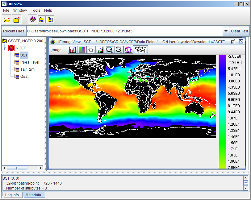
HDF-EOS5 Grid Visualization on Map
-
Please download the sample
GSSTF_NCEP.3.2008.12.31.he5 file.
-
Select File > Open menu to open the sample file. Expand NCEP grid to display fields (datasets) inside the NCEP grid.
-
Using right mouse button, click the SST field name.
-
Select Open As from the pull-down menu.

- Select Rainbow palette. Press OK button.

- Zoom out the image by pressing the
 icon.
icon.

-
Click the world coastline
 icon.
A new dialog box will appear.
Choose WHITE color and press OK.

-
Fill value is not handled correctly. You can correct it by selecting Image > Set Value Range.
Set the Lower Bound value to -2.
- Image is upside down. You can correct it by selecting Image > Flip > Vertical. The below is the final image after fill value correction and flip operation.

Limitations
- The HDF-EOS2 to HDF-EOS5 file conversion has not been tested on many different products; therefore, it may have some minor problems.
- Visualization on map is limited to Grid. Swath will not work.
-
Some upside-down HDF-EOS5 Grid products such as
OMI-Aura_L3-OMTO3e_2005m1214_v002-2006m0929t143855.he5
file cannot be visualized on map correctly.
See Also
References
-
HDF-EOS Plug-in README
https://wiki.earthdata.nasa.gov/display/DAS/HDFView2.10+Plug-in+README
Last modified: 08/17/2023


